The Kedarnath trek is 18 km uphill, at 3,500 metres, on a mountain trail that gets cold, steep, and unforgiving past the halfway mark. People have their own reasons for doing it — faith, adventure, bucket list, family tradition. Whatever yours is, the mountain doesn’t care. What matters is whether you’ve prepared for it.The trek starts from Gaurikund — a small pilgrim town at 1,982 m in the Rudraprayag district. From there to Kedarnath Temple (3,583 m) is roughly 18 km on the new post-2013 route. The original trail was destroyed in the Kedarnath floods of June 2013. The rebuilt path is longer and more open than the old one, with proper signage and checkpoints throughout.
Lakhs of pilgrims complete this trek every season — elderly people, children, first-timers. It’s not impossible. But it asks for more than most people give it credit for.
Trek at a Glance
| Detail | Information |
| Starting Point | Gaurikund (~1,982 m / 6,500 ft) |
| Destination | Kedarnath Temple (~3,583 m / 11,755 ft) |
| Trek Distance | ~18 km one-way |
| Duration | 6–8 hours up | 4–6 hours down |
| Difficulty | Moderate to Strenuous |
| Trek Timing | Start: from 4:00 AM | Last departure from Gaurikund: 1:30 PM |
| Best Season | May–June and September–October |
| Key Stops | Jungle Chatti, Bheem Bali, Rambara, Lincholi, Rudra Point |
| En Route | Medical posts, rain shelters, food stalls, water points |
| Mobile Network | BSNL and Jio — works till Bheem Bali, patchy after that |
| If You Can’t Trek | Pony, Palki, Kandi, Helicopter (Phata / Sirsi / Guptkashi) |
| Registration | Mandatory — registrationandtouristcare.uk.gov.in |
| Register before you travel:
Online registration on registrationandtouristcare.uk.gov.in is mandatory. Print your Yatra Pass and carry it — checkpoints check for it and will turn you back without one. The photometric counter at ISBT Rishikesh still works for walk-ins, but during May–June it gets jammed. Doing it online from home is the easier route. |
Starting the Trek — What Actually Happens
Most people arriving at Gaurikund for the first time are surprised by how busy it is before sunrise. The Dhabas are open. Ponies are lined up. Pilgrims in service of the mountain — local porters, guides, pony handlers — are already at work. The government booking counter opens early morning.
If anyone in your group needs a pony or Palki, book it at the government counter right when you arrive — not later. By 8–9 AM, availability is unpredictable and you’re dealing with private operators at roadside rates. Government-fixed rates apply at the official counter only.
The trek starts forested and gradual. Jungle Chatti at 6 km is where most people take their first real break. After that, past Rambara Bridge, the landscape changes — more open, more exposed, and noticeably steeper. This is also where altitude starts to make itself felt, especially for people who pushed the first half too fast.
One thing the old guides never mention — the last kilometre before the temple, after Base Camp, is almost flat. When you see the temple spire appear in front of you against the Kedarnath peak, that’s the moment most pilgrims stop walking and just stand there for a bit.
Suggested to Read:
Route Breakdown — Segment by Segment
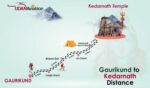
- Gaurikund → Jungle Chatti: 6 km. Forested trail, steady climb. Tea stalls available at Jungle Chatti. This is the gentlest stretch — use it to find your pace, not to go fast.
- Jungle Chatti → Bheem Bali (via Rambara): ~4 km. Crosses the Mandakini River at Rambara Bridge. Rambara has food, water, first aid, and is a proper rest stop — not just a bridge.
- Bheem Bali → Lincholi: ~3 km. Steeper here. Most people start feeling the altitude in this section. Go slow.
- Lincholi → Base Camp: ~4 km. Open terrain with mountain views. The trail widens at Base Camp.
- Base Camp → Kedarnath Temple: ~1 km. Almost flat. The temple comes into view from here.
Total: ~18 km one-way. Going up — 6 to 8 hours at a normal pace. Coming back down — 4 to 6 hours.
| Rambara — more than a bridge:
Rambara is the midpoint of the trek and a proper rest stop. Food stalls, water, basic first aid are all here. Sit down properly, eat something, drink water. The trail gets harder after this point. If you’re already feeling off — headache, heavy breathing, stomach issues — this is the right place to address it, not 3 km higher up. |
All 10 Checkpoints on the Kedarnath Trek
| # | Checkpoint | Distance from Gaurikund | Altitude |
| 1 | Gaurikund | 0 km — Start | ~1,982 m / 6,500 ft |
| 2 | Jungle Chatti | ~6 km | ~2,600 m |
| 3 | Bheem Bali | ~10 km | ~3,100 m |
| 4 | Rambara Bridge | ~8 km | ~2,590 m |
| 5 | Chhota Lincholi | ~11 km | ~3,200 m |
| 6 | Lincholi | ~13 km | ~3,360 m |
| 7 | Chhani Camp | ~14 km | ~3,450 m |
| 8 | Rudra Point | ~15 km | ~3,500 m |
| 9 | Base Camp | ~17 km | ~3,553 m |
| 10 | Kedarnath Temple | ~18 km — End | ~3,583 m / 11,755 ft |
Before You Start — Things Worth Knowing
About the Timing
The trek opens at 4 AM from Gaurikund. The last permitted departure is 1:30 PM — after that, no one is allowed to start. People who leave after 10 AM on an 18 km climb are already cutting it short on daylight.
If you reach Kedarnath and it’s getting dark — stay the night at one of the camps along the route (Jungle Chatti, Bheem Bali, Lincholi). Trying to descend a mountain trail in the dark because you don’t want to pay for a tent is a bad trade.
Physical Preparation
Two weeks of daily walking makes a noticeable difference. Not marathon training — just 45 minutes of walking or stairs every day in the lead-up. People who do this consistently say the first half of the trek feels manageable. People who don’t say it didn’t seem that far on the map.
- If you’re above 50, or have heart disease, high BP, asthma, or diabetes — get a doctor’s check-up specifically for high-altitude travel before booking. Not as a formality.
- Ponies, Palkis, and helicopters exist for people who can’t trek. Using them is not a lesser version of the Yatra.
Altitude Sickness — What You Need to Know
Kedarnath is at 3,583 m. AMS — Acute Mountain Sickness — can affect anyone at this height, regardless of age or fitness. It’s more common than people think, and the dangerous part is that it often starts mild.
The typical pattern: a headache comes on somewhere past Bheem Bali. The person drinks some water and walks it off. Headache doesn’t go away. By Lincholi it’s worse, maybe with nausea now. They keep walking because they’ve come this far. That’s where it goes wrong.
| AMS symptoms to watch for:
Headache that keeps getting worse despite rest and water. Nausea or vomiting. Dizziness. Shortness of breath even when sitting still. Confusion, unusual exhaustion, loss of appetite. If two or more of these appear together — stop. Sit down, drink water slowly. If symptoms don’t ease in 30 minutes, start descending. Medical posts are staffed along the route and at Kedarnath. |
To reduce the risk: don’t rush the ascent, drink water steadily through the day (not all at once), skip alcohol from the night before, eat light on the trek day, and if your schedule allows — spend a night in Guptkashi before Gaurikund to give your body time to adjust.
What’s Available on the Trail
- Pony, Palki, Kandi: Book at the government counter in Gaurikund or Sonprayag. Rates are regulated. Kandi is the basket carrier for those who can’t sit upright in a palki. Demand is very high in May — book early morning.
- Food and water: Dhabas and tea stalls at Jungle Chatti, Bheem Bali, Rambara, Lincholi. Carry 2 litres of water from Gaurikund regardless — don’t depend on stalls being open or having stock.
- Overnight camps: Tented accommodation at Jungle Chatti, Bheem Bali, Lincholi. Basic but functional. Useful if you’re doing the trek over two days.
- Medical posts: First aid at multiple points. Oxygen cylinders at higher checkpoints. For serious emergencies, helicopter evacuation can be arranged through checkpoint staff.
- Mobile signal: BSNL and Jio work till around Bheem Bali. After that, don’t count on it. Download offline maps before leaving — Google Maps offline or Maps.me both work.
Helicopter to Kedarnath
Three helipads serve Kedarnath. Phata is the most popular — closest to the temple and usually the cheapest. All three are weather-dependent, which means cancellations happen, sometimes without much notice.
| Helipad | Distance from Kedarnath | One-Way Fare (Approx.) | Booking |
| Phata | ~12 km | Rs. 4,000 – 6,000 per person | IRCTC portal / operator |
| Sirsi | ~14 km | Rs. 4,500 – 6,500 per person | IRCTC portal / operator |
| Guptkashi | ~30 km | Rs. 6,000 – 8,000 per person | IRCTC portal / operator |
May–June slots get booked weeks out. If you’re planning to fly, sort the booking before you leave home — not from a hotel in Rishikesh the night before. And before paying, ask the operator in writing: what happens if the flight is cancelled? Do they reschedule, refund, or offer a road alternative? The answer to that question tells you a lot about the operator.
What to Pack
The rule on the Kedarnath trek is simple — if you’re not sure you’ll use it, leave it behind. 18 km of uphill climbing turns every unnecessary kilo into a regret.
- Trekking boots: Waterproof, ankle support, rubber grip. The trail has rocky sections, wet patches, and loose stone. Sneakers and casual shoes are a bad idea from km 3 onwards.
- Warm clothing: Thermal inner, fleece jacket, windproof shell. Cap, gloves, thick socks. In May, Kedarnath can drop to 2–4°C overnight. June is warmer but still cold after sunset.
- Rain poncho: Weather in the mountains shifts fast. A poncho that fits in your pocket adds almost no weight and saves you a miserable hour if it rains.
- Trekking pole: On the descent especially, a pole takes a lot of pressure off your knees. Worth carrying even if it feels unnecessary going up.
- Water and food: 2 litres minimum from the start. Dry fruits, glucose biscuits, energy bars, ORS sachets. Eat small amounts regularly on the trail rather than one big meal.
- Sunscreen and sunglasses: UV exposure at 3,000+ metres is severe — much worse than at sea level. A few hours without sunscreen at this altitude can leave you burned badly.
- Medicines: Paracetamol, Diamox (talk to your doctor before carrying this), anti-nausea tablets, antacids, cold medicine, basic first aid. Buy everything before leaving home.
- Documents: Printed Yatra Pass, Aadhaar or Passport in a waterproof pouch.
- Headlamp and power bank: The 4 AM start is dark. Headlamps are not optional for early starters. A power bank matters because charging points on the trail are rare.
Safety Tips — Straight Points
- Start at 4 AM. The 1:30 PM cutoff at Gaurikund exists because people need daylight to complete 18 km and come back safe.
- Stay on the marked path. Off-trail shortcuts cause most of the accidents on this route every season.
- Don’t do this alone if it’s your first time. Go with the group or hire a local guide at Gaurikund.
- Drink water steadily — 3 to 4 litres through the day. Don’t wait until you’re thirsty at altitude.
- Stop if you feel sick. AMS gets worse the higher you go, not better. Descend if symptoms don’t improve after 30 minutes of rest.
- The weather at Gaurikund and at Kedarnath can be completely different — there’s 1,600 m of altitude between them. Ask locals at the checkpoint before starting, not a weather app.
- Save 1077 (Uttarakhand Disaster Helpline) and 112 (SDRF) in your phone before the trek day.
The Return — Coming Back Down
The descent to Gaurikund takes 4–6 hours. It’s physically different from climbing — your legs stay under less strain but your knees absorb more impact on the downhill slopes. People who rushed the ascent often feel this harder.
Leave Kedarnath by 2 PM at the latest if you’re returning the same day. That’s not a wide buffer on a 4–6 hour descent — it’s just enough.
- Trekking poles are useful here — reduce the impact on your knees on steep sections.
- Take a 10-minute break roughly every 45 minutes. Leg cramps on long descents are common when you push without stopping.
- Ponies and palkis are bookable for the return at Kedarnath — worth arranging before you leave the temple area if you need one.
- If you stayed overnight at Kedarnath, starting the descent by 6 AM gives you a comfortable window and cooler temperatures for the first few hours.
Best Time to Visit
| Season | Months | Conditions | Verdict |
| Opening | May – June | Clear weather, 5–15°C daytime. Peak crowd season — especially mid-May onwards. | Good, but expect queues. Book stays well in advance. |
| Monsoon | July – August | Heavy rain, slippery trail, landslide risk, road closures. | Risky. Most experienced trekkers skip this window. |
| Post-Monsoon | September – October | Best visibility of the year. Fewer pilgrims, crisp air, clear mountain views. | Excellent. Often better than May for first-timers. |
| Closing | November | Snowfall starts, temple closes for winter around Diwali. | Last chance — confirm closing date before planning. |
September and October are worth considering seriously. The monsoon is over. The Himalayan views at this time of year are noticeably clearer. The trail is much less crowded than May. Many pilgrims who’ve done the trek multiple times quietly choose this window over the opening season.
Kedarnath — Distance from Major Cities
| City | Distance | City | Distance | City | Distance |
| Haridwar | 239 km | Delhi | 452 km | Rishikesh | 216 km |
| Dehradun | 254 km | Badrinath | 215 km | Sonprayag | 24 km |
| Haldwani | 327 km | Chandigarh | 443 km | Gangotri | 220 km |
| Lucknow | 748 km | Jaipur | 740 km | Pune | 1,963 km |
| Mumbai | 1,928 km | Nainital | 310 km | Guptkashi | 47 km |
| Indore | 946 km | Mussoorie | 260 km | Ahmedabad | 1,429 km |
| Agra | 649 km | Kanpur | 902 km | Phata | 32 km |
| Rudraprayag | 88 km | Jammu | 788 km | Ludhiana | 510 km |
| Uttarkashi | 335 km | Varanasi | 1,226 km | Kolkata | 1,898 km |
Frequently Asked Questions
Q1. Can someone who has never trekked before do the Gaurikund to Kedarnath trek?
Yes. But it’s 18 km uphill at altitude — not comparable to a hill station walk. The honest advice: start walking daily for 2–3 weeks before the trip, at least 45 minutes a day. On the trail, go at your own pace, stop at Jungle Chatti and Rambara for proper breaks, and don’t try to match faster walkers. If you need a pony or palki partway, that’s what they’re there for.
Q2. What shoes work for the Kedarnath trek?
Waterproof trekking boots with ankle support. The path has rocky stretches, wet patches, and uneven stone — especially past Rambara. Sneakers can get you to Jungle Chatti but they’re a liability further up. If you don’t own trekking boots, buy or rent them before you reach the mountains — not from a roadside stall in Sonprayag the morning of the trek.
Q3. What is the trail like?
The first 6 km to Jungle Chatti goes through forest with a gradual incline. After Rambara Bridge it gets steeper and more open. Between Bheem Bali and Lincholi is where altitude starts affecting people who pushed too hard in the first half. After Lincholi, it’s open mountain terrain with views of the surrounding peaks until Base Camp. The last kilometre to the temple is almost flat.
Q4. What safety precautions should I keep in mind?
Start at 4 AM. Stay on the marked trail only — off-path shortcuts cause most accidents here. Don’t trek solo on your first time. Drink 3–4 litres of water through the day. Watch yourself and your group for AMS symptoms (persistent headache, nausea, dizziness). If symptoms appear, rest immediately and descend if they don’t ease. Uttarakhand helpline: 1077. SDRF: 112.
Q5. Is registration compulsory for the Kedarnath trek in 2026?
Yes, for all pilgrims. Register at registrationandtouristcare.uk.gov.in before your travel date. Carry the printed Yatra Pass — checkpoints on the route check for it. If you show up without one, you’ll be turned back. Walk-in registration is available at Rishikesh and Sonprayag, but it gets crowded during peak season. Online is faster.
Q6. What helicopter options are available for Kedarnath?
Three helipads — Phata (~12 km from the temple), Sirsi (~14 km), Guptkashi (~30 km). One-way fares range from roughly Rs. 4,000 to Rs. 8,000 per person. May–June slots go fast — book through the IRCTC portal or a registered operator well before your travel date. Flights are weather-dependent and cancellations are common. Check the operator’s cancellation and refund terms before paying.
Q7. What is the last time to start the trek from Gaurikund?
1:30 PM is the cutoff. If you’re arriving at Gaurikund in the afternoon, plan to rest and start at 4 AM the next day. Starting at noon or later on an 18 km mountain trek means you’re likely trekking in the dark — which is both dangerous and not permitted.
Q8. Can elderly people visit Kedarnath?
Yes. Pony, Palki, Kandi (porter basket), and helicopter services are specifically available for those who can’t trek. The helicopter is the fastest and most comfortable option. For elderly pilgrims who want to walk, it’s possible at a slow pace — but a medical check-up before travelling to altitude above 3,000 m is important, not optional.
Q9. Is overnight stay available on the trek route?
Yes — basic camps and tented guesthouses at Jungle Chatti, Bheem Bali, and Lincholi. Breaking the trek into two days is a reasonable choice, especially for older pilgrims or those who haven’t trekked before. Many people do it this way intentionally.
Q10. My helicopter was cancelled due to weather. What should I do?
Ask your operator specifically about cancellation policy before you pay — not after. Good operators reschedule for the next available day or offer road transport as an alternative. Some don’t. Get the terms confirmed in writing or over a documented call. ‘We’ll take care of it’ is not a policy.

Kedarnath
har har mahadeb