Planning the Char Dham Yatra route is something you should do well before you actually leave. Because this isn’t just a trip — it’s a commitment. The full circuit from Haridwar to Badrinath and back covers roughly 1,600 km. Along the way, you’ll deal with narrow mountain roads, mandatory treks, and weather that changes without warning.
People who show up unprepared either get stopped at a checkpoint because they skipped registration, or they reach Gaurikund and realize their footwear won’t survive a 16 km trek. Both situations are completely avoidable. All it takes is a little planning before you leave home.
This guide covers everything you actually need — distances, road conditions, route details, registration, and tips that come from ground-level experience, not just a map.
Char Dham Yatra Registration 2026 — Do This First, Everything Else Can Wait
Before you book hotels, before you plan which route to take — complete your online registration. After the devastating 2013 Kedarnath floods, the Uttarakhand government made registration mandatory for all pilgrims. Without a valid e-pass, you will be stopped at checkpoints like Dobata, Phata, Sonprayag, and Pandukeshwar. No exceptions.
The good news — registration is completely free.
| Detail | Information |
|---|---|
| Official Portal | registrationandtouristcare.uk.gov.in |
| WhatsApp Registration | Type “Yatra” and send to +91-8394833833 |
| Helpline Number | 0135-1364 |
| Offline Counters | Haridwar, Rishikesh, Dehradun, Uttarkashi, Sonprayag, Gaurikund |
| Registration Opened | 6 March 2026 |
Documents you’ll need:
- Any valid government ID — Aadhaar, Voter ID, Passport, PAN Card, or Driving License
- Passport-size photo or a clear selfie
- Active mobile number for OTP
- Health declaration form
Once registered, you receive a QR-coded e-pass on both SMS and email. Keep it on your phone or carry a printed copy — officials scan it at every major checkpoint.
⚠️ Watch out for this: Near bus stands in Haridwar and Rishikesh, people offer “registration help” for ₹100–₹500. Don’t pay anyone. The process is entirely free and no one is authorized to charge for it.
Char Dham Yatra Route Map — Distance and Time at a Glance
| Route | Distance | Travel Time |
|---|---|---|
| Delhi to Haridwar | ~230 km | 5–6 hours (road, NH334) |
| Haridwar to Barkot | 180 km | 5–6 hours |
| Barkot to Janki Chatti (Road) | ~45 km | 1.5–2 hours |
| Janki Chatti to Yamunotri (Trek) | 6 km | 3–4 hours |
| Barkot to Uttarkashi | 82 km | 2.5 hours |
| Uttarkashi to Gangotri | 100 km | 2.5 hours |
| Uttarkashi to Guptkashi | 196 km | 7–8 hours |
| Guptkashi to Gaurikund | 30 km | 1–2 hours |
| Gaurikund to Kedarnath (Trek) | 16 km | 6–8 hours (trek) / 3–4 hours (pony or palanquin) |
| Guptkashi to Badrinath | 200 km | 6–7 hours |
| Badrinath to Rudraprayag | 150 km | 4–5 hours |
| Rudraprayag to Haridwar | 150 km | 4–5 hours |
Chardham Road Map from Delhi
Delhi to Haridwar — ~230 km / 5–6 hours
Take NH334 from Delhi — that’s the current highway. The old NH1 and NH58 designations no longer officially exist after India’s national highway renumbering in 2016. Any blog still mentioning NH58 is working off outdated information.
The road is in good condition throughout. The only real delay is getting out of Delhi itself — an early morning departure makes a noticeable difference.
Haridwar to Yamunotri — 180 km road + 6 km trek / 7–8 hours
From Haridwar, the route goes through Rishikesh, Tehri, Barkot, and finally Janki Chatti — where the road ends and the trek begins. It’s a 6 km walk up to Yamunotri temple, taking about 3–4 hours at a comfortable pace.
On the ground — pony operators at Janki Chatti negotiate aggressively. Fix the rate before you start. Don’t agree to “we’ll settle at the top.”
Yamunotri to Gangotri — 225 km / 7–8 hours
Back down to Janki Chatti, then through Barkot, Dharasu, and Uttarkashi. Uttarkashi is a sensible overnight stop if the timing doesn’t work out. The road from Uttarkashi to Gangotri is scenic but narrow in sections — take it slow.
One practical thing most people miss — fill up your fuel tank at Uttarkashi. Reliable petrol pumps after this point are scarce, and running low on mountain roads is not a situation you want to be in.
Gangotri to Kedarnath — ~250 km road + 16 km trek / 10–12 hours
This is the longest and most demanding leg of the entire yatra. From Gangotri, you drive through Rudraprayag and Guptkashi to reach Gaurikund. From there, the 16 km trek to Kedarnath begins.
Some articles still say “20 km trek” — that’s wrong. The correct distance is 16 km. The first 5 km are the steepest. After that the trail levels off a bit, but it never gets easy. If you’re not a regular walker, start preparing at least 3–4 weeks before your trip.
Kedarnath to Badrinath — 220 km / 8–9 hours
From Gaurikund, drive back through Rudraprayag, Karnaprayag, and Chamoli to reach Badrinath. The road is in reasonable condition throughout. The stretch from Joshimath onwards is particularly beautiful — on a clear day, Neelkanth Peak is visible in the distance.
Char Dham Yatra Road Map from Dehradun
Dehradun to Barkot — ~160 km / 4–5 hours
Start on NH-7 from Dehradun and follow the route through Rishikesh, Narendra Nagar, Kirti Nagar, and Chamba before reaching Barkot. From Barkot, it’s another ~45 km to Janki Chatti where the Yamunotri trek starts.
Worth mentioning — several older blogs mention “Nashik” as a waypoint on this route. Nashik is in Maharashtra. There is no place called Nashik on the Dehradun–Yamunotri route. That was a copy-paste error that spread across multiple websites.
Barkot to Gangotri — ~120 km / 5–6 hours
From Barkot, head to Uttarkashi and then follow the road to Gangotri via Harsil. The Bhagirathi river runs alongside the road for a good stretch — the views are genuinely worth slowing down for. Harsil itself is a beautiful village. If you have the option to spend a night there, do it.
Gangotri to Kedarnath — 250–270 km / 9–10 hours
From Gangotri, drive through Uttarkashi, Tehri, and Rishikesh to reach Gaurikund. Then it’s the 16 km trek up to Kedarnath. Plan to arrive at Gaurikund by late afternoon at the latest — starting the trek in the dark is not recommended.
Kedarnath to Badrinath — 220–250 km / 9–10 hours
From Gaurikund, drive through Joshimath and Chamoli to reach Badrinath. If time permits, a night in Joshimath breaks the journey nicely and gives you time to acclimatize before Badrinath.
Road Conditions — Dham by Dham
Yamunotri
Delhi to Haridwar — smooth, well-maintained highway. No issues. Haridwar to Barkot — narrower in sections, some sharp bends, but manageable with a careful driver. Barkot to Janki Chatti — this is where it gets genuinely challenging. The road is very narrow with steep climbs and tight turns. Not the place to rush.
- Altitude: 3,291 meters
- Places to visit: Yamunotri Temple, Saptarishi Kund, Surya Kund, Divya Shila, Hanuman Chatti, Kharsali
Gangotri
Yamunotri to Uttarkashi — good road, a few narrow stretches but nothing alarming. Uttarkashi to Gangotri — mostly smooth, scenic, but narrow with sharp curves in places. During heavy rain, landslides are possible on this stretch. Always check weather advisories before heading out.
- Altitude: 3,100 meters
- Places to visit: Gangotri Temple, Bhaironghati, Gangnani, Kedartal, Gaumukh
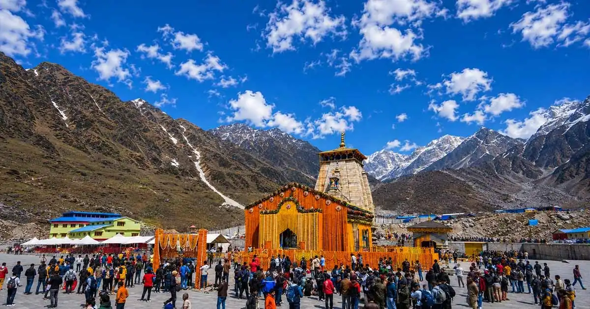
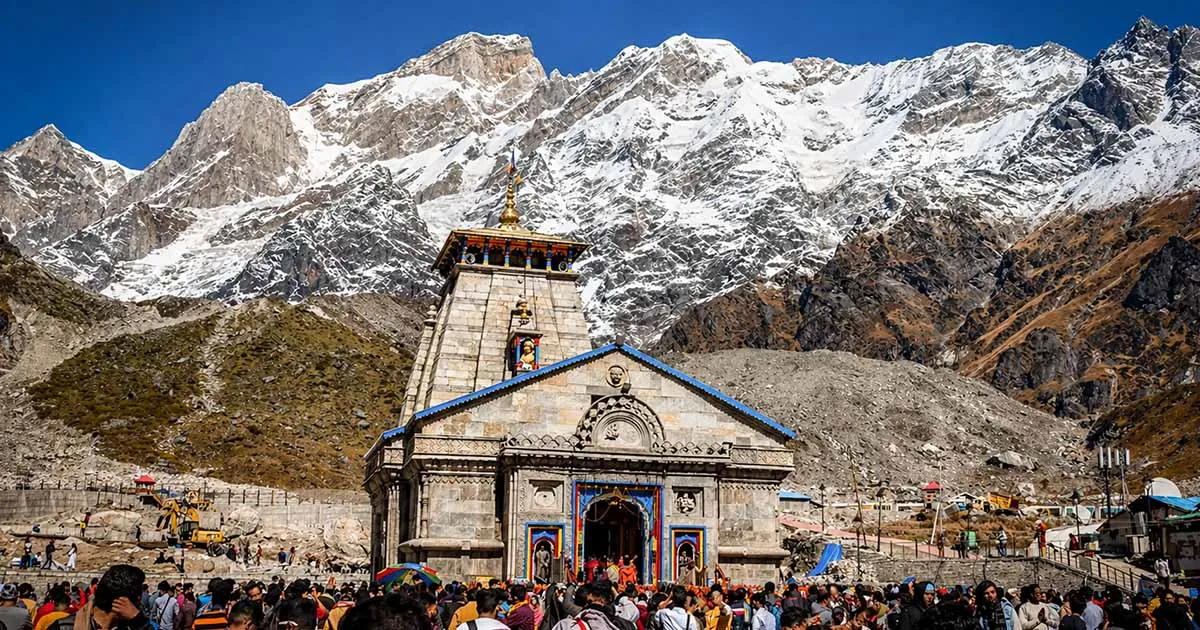
Kedarnath
Gangotri to Rudraprayag — good condition for the most part, winding in sections. Rudraprayag to Gaurikund — narrow, steep, requires full attention. And then the trek itself — 16 km of mountain trail at over 3,500 metres. It’s the most physically demanding part of the entire Char Dham circuit.
Pony and palanquin services are available at Gaurikund. During peak season, expect a wait of 3–4 hours. Book in advance if possible.
- Altitude: 3,583 meters
- Places to visit: Kedarnath Temple, Gandhi Sarovar, Vasuki Tal, Shankaracharya Samadhi
Badrinath
Gaurikund to Rudraprayag — narrow roads, careful driving required throughout. Rudraprayag to Badrinath — mostly smooth but monsoon brings landslide risk, particularly near Lambagad. Badrinath is the most accessible of all four dhams — the road goes straight to the temple, no trek needed. That’s also why it tends to have the largest crowds.
- Altitude: 3,133 meters
- Places to visit: Badrinath Temple, Tapt Kund, Neelkanth Peak, Mana Village, Vyas Gufa
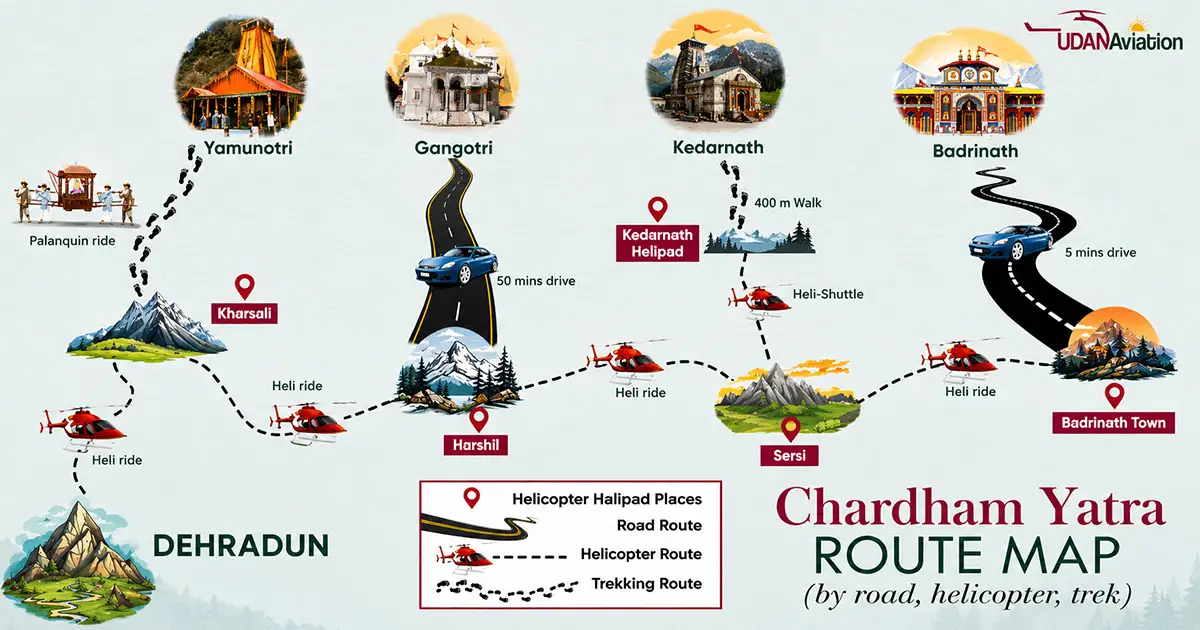
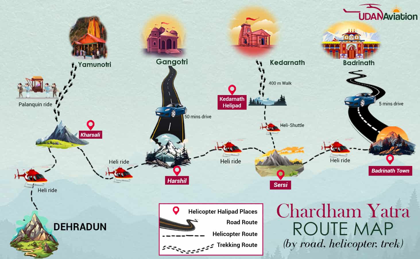
Char Dham Helicopter Route Map from Dehradun
For senior citizens, pilgrims with health conditions, or anyone with limited time — the helicopter route is a legitimate and genuinely comfortable option. All four dhams, darshan included, in about 5 days.
| Sector | Flying Time |
|---|---|
| Sahastradhara (Dehradun) → Yamunotri | 45–50 minutes |
| Yamunotri → Gangotri | 30 minutes |
| Gangotri → Kedarnath | ~1 hour |
| Kedarnath → Badrinath | ~50 minutes |
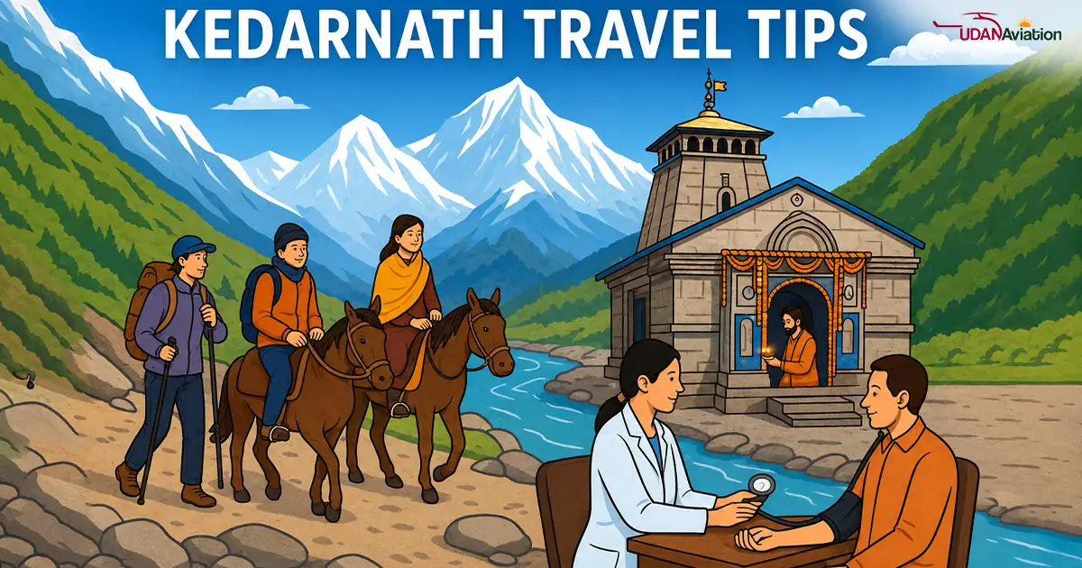
Travel Tips
Get physically ready — and mean it. The Kedarnath trek is 16 km at 3,583 metres. It’s not a casual walk. Start daily walking of at least 5 km about a month before your trip. Use stairs instead of lifts. Light jogging and yoga help too. Pilgrims who aren’t physically prepared often have to turn back mid-trail — and that’s a genuinely disappointing experience after travelling so far.
Pick your season carefully. May–June is peak season — full facilities, open roads, but heavy crowds everywhere. September–October is the sweet spot — fewer pilgrims, clear skies, snow-capped peaks in full view. July–August should be avoided if possible. Heavy rains and landslides are frequent during this period, and roads can close without notice.
Pack smart, not heavy.
- Warm layers — nights above 3,000 metres get cold even in May
- Comfortable, worn-in trekking shoes — never attempt the trek in new shoes
- Raincoat or compact poncho — always
- Personal medicines plus a basic first aid kit
- Power bank — charging points are limited on the route
- Offline maps downloaded before you leave — mobile networks disappear frequently in the mountains
Take altitude seriously. Kedarnath at 3,583 m and Badrinath at 3,133 m are both high enough to cause altitude sickness in unprepared people. Don’t overexert on Day 1. If you feel breathlessness, headache, or nausea — rest immediately, don’t push through it. Spending a night in Uttarkashi before Gangotri, or in Joshimath before Badrinath, genuinely helps your body adjust.
Respect the place. Char Dham Yatra is a deeply sacred circuit. Dress modestly at all temples — shoulders and knees covered for both men and women. Follow temple rules. Don’t litter. The Himalayas belong to everyone who comes after you.
Safety Rules
Do’s
- Walk slowly on the trek. Speed increases altitude sickness risk. There’s no prize for finishing first.
- Hire an experienced hill driver. Mountain roads — especially the Barkot and Gaurikund stretches — require someone who knows them well.
- Keep energy up on the trek. Water with a pinch of sugar and salt works surprisingly well for sustained energy — better than most commercial drinks.
- Carry a first aid kit and a walking stick. Especially important for the Kedarnath trail.
- Carry cash after Rishikesh. Cards and UPI are unreliable beyond this point. Withdraw cash at Rishikesh or Uttarkashi — ATMs further up are not dependable.
Don’ts
- Don’t store petrol, gas, or kerosene in your vehicle. On mountain roads, this is a serious safety hazard.
- Don’t take shortcuts on the trek. Even if a local suggests a faster trail — stick to the approved route. Unauthorized paths carry landslide and navigation risks.
- Don’t trek alone. Never separate from your group on the trail. Solo walking in hilly terrain can go wrong quickly.
- Don’t board unregistered vehicles. Travel with recognized operators or official government transport only.
- Don’t drive after 7 PM on mountain roads. Night driving on the Rishikesh–Badrinath or Uttarkashi stretch is dangerous. Plan your halts accordingly.
FAQs
Q-1: What is the nearest airport and railway station for Char Dham Yatra?
Jolly Grant Airport in Dehradun is the nearest airport. For trains, book to Haridwar Railway Station or Rishikesh Railway Station — both are well-connected to Delhi and other major cities.
Q-2: Is road travel safe for Char Dham Yatra?
Yes, with proper planning. Always check weather forecasts before starting. Landslide risk is highest between July and August. Avoid driving on mountain stretches after 7 PM.
Q-3: Is there a specific order for visiting the four dhams?
Ans: According to Hindu tradition, the circuit should be completed west to east — Yamunotri → Gangotri → Kedarnath → Badrinath. That said, pilgrims can adjust the sequence based on practical convenience.
Q-4: How long does the full Char Dham Yatra take?
Ans: By road, the traditional route comfortably takes 10–12 days. By helicopter, it can be completed in 5 days. Trying to do it in 7–8 days by road is possible but leaves little margin for weather delays or rest — and both matter at this altitude.
Q-5: Is budget accommodation available along the route?
Ans: Yes. Ashrams, guesthouses, dharamshalas, and lodges are available throughout. For May and June, book in advance — accommodation fills up fast during peak season.
Q-6: Is hiring a guide necessary?
Ans: Not mandatory. But for the Kedarnath and Yamunotri treks — especially for first-time visitors — a local guide is worth it. They know the trail, the conditions, and who to call in an emergency.
Q-7: Is Char Dham registration free in 2026?
Ans: Yes, completely free. Register at registrationandtouristcare.uk.gov.in. Don’t pay anyone offering to do it for you. Registration has been open since 6 March 2026.
Q-8: Is registration required for helicopter yatra too?
Ans: Yes. Registration is mandatory regardless of how you travel. Complete registration on the official portal first, then book your helicopter at heliyatra.irctc.co.in.
Conclusion
Char Dham Yatra — Yamunotri, Gangotri, Kedarnath, Badrinath — is one of those journeys that stays with you long after it’s over. The scale of the Himalayas, the rivers, the altitude, the quiet inside the temples — none of it translates properly into words. You have to be there.
But it rewards the people who come prepared. Register first — it’s free and it’s mandatory. Get physically ready, especially for Kedarnath. Pick your season wisely — May–June or September–October. Carry cash beyond Rishikesh. And don’t drive after dark on mountain roads.
Everything else tends to sort itself out on the road. When you finally stand at Badrinath with Neelkanth Peak visible in the distance — every kilometer of that journey makes sense.